Week 5 – Locative Narrative + Actionbound (Miriam Harvey)

“spaces we move through are media that tell stories” (Ritchie, 2013)

Ritchie (2014:53) describes “transmedia” stories [which] “blur the line between storyworld and physical world, requiring that authors tell stories across a variety of media, including architectural space and the physical environment.” My case study this week is an actionbound I have built on a web browser and played on a mobile phone to gain first hand experience of designing and using media that can “blur the line between storyworld and physical world”.

My actionbound topic is a dog walk, because it is a daily activity which does not obviously or intrusively involve technology. The walks are a simple physical exercise, so I was interested to see how the actionbound I designed could add a new dimension of “navigating across digital and physical spaces” (Ritchie, 2014: 65).

Ritchie (2014: 55) explains that “design choices and materials of everyday things afford and constrain the behaviors of users”. In this case study, the affordance I experienced from playing the bound was the gamification. An uneventful walk through quiet streets and empty parkways became a game, and therefore more interesting. There was though an effort required to play the game, which Ritchie (2014: 57-56) describes as “”nontrivial effort””. He warns that “the narrative must offer a reward perceived to be greater than the effort required by the audience” and I don’t think my simple actionbound achieved that.

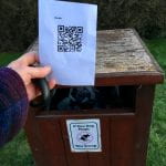
My actionbound started with an ‘information’ screen to introduce the bound and a ‘mission’ to ‘evidence’ that the player was ready for the dog walk by uploading a photograph taken on the phone’s camera of poo bags and a dog lead. It included a ‘find spot’ [figure 1] using the phone’s ability to use GPS and a map displayed in the app; a second ‘mission’ to find a specific location based on text description and a photograph [figure 2] and upload a similar photograph. There was also a ‘scan code’ [figure 3] to ‘evidence’ that a poo bin was reached in the trail. It concluded with a ‘quiz’ to gauge the time taken to complete the dog walk. The results can be seen in Figure 4.


The experience of playing the bound made me aware of the two distinct worlds of the digital space and physical space. For most of the walk, the digital space was a passive overlay on the physical environment. The “digital bridges” (Ritchie: 2014: 63-64) of finding a spot through GPS and map or text description and photograph, and scanning QR code were active elements that made the story more engaging as a user and demonstrated the “co-authoring” (Ritchie: 2014: 65) aspect of transmedia storytelling.

The actionbound was played in public areas – public roads and public parks, maintained by the local town authorities. I felt like I was appropriating public space for private use when playing the game because I was using the space in a manner that is different to the way I expect it is intended. Adding a QR code to a poo bin was the strongest appropriation because I was making a (temporary) physical change to public property. Berry et al (2013:3-5) points out that there are many ways to understand the term “public” and “[t]he traditional idea of space … has become fundamentally problematized by the presence of media distributing and redirecting data flows that transverse the boundaries of an enclosure”.  Therefore, what I perceived as a private use of a public space could instead be understood as a creation of a new dimension of a public space; the production of a “heterogeneous space” that is “comprised of diverse things and qualities”.


References

Berry, C., Harbord, J. & Moore, R.O., (2013). Public space, media space, Basingstoke: Palgrave Macmillan

Ritchie, J. (2013). Ch. 4: Wayfinding on Campus, The mobile story. Available from: http://themobilestory.com/ch-4-wayfinding-on-campus/

Ritchie, J. (2014). The Affordances and Contraints of Mobile Locative Narratives. In The Mo- bile Story. Narrative Practices with Locative Technologies, ed. J. Farman, 53–67. Oxon: Routledge.


Week 5: Locative Narrative & Actionbound

Having lots of history around my area, I wanted to create a Bound that would allow the ‘reader’ to discover historical locations in Brighton.

Upon testing my Bound, I knew immediately that I had not included enough directional information or context to the locations I was giving. All that was available to me, as the test reader, was a directional arrow followed by a request to take a picture of where the arrow had taken me to. Not suitable for someone new wanting to learn about the area. This was the key constraint that I found when testing my Bound, a semantic constraint (Ritchie, 2014: 55) caused by not giving enough meaning to the space I was asking the player to move through. As Ritchie notes: “The events of the story influence the audience’s understanding of different spaces in which the story takes place.” (2014: 65) By not giving enough information on events of both Brighton’s history or the events of the Bound (i.e where the next location was) the Bound itself became a meaningless trek through unfamiliar space, and lost the narrative that the Bound was intended to create.

Not the best weather for it!

In my Bound I included links to local websites (The Argus, Brighton Museums) which gave more detailed information about the locations featured in the Bound. I also added some ‘Quiz’ questions about the locations such as names and dates, meaning the reader must engage with the online links alongside the buildings to continue the Bound. The reader moves through both digital and physical spaces simultaneously to push the narrative forward. This links to Ritchie’s ‘narrative value threshold’: “digital media has more interactivity, so the audience has to put more effort in to continue the narrative and complete the ‘story’.” (2014: 57) Actionbound is the perfect example of a transmedia narrative that requires a higher narrative value threshold.

13 Victoria Street, the final location in my Bound

By using Actionbound in any given location, it changes the nature of the space we experience. Actionbound is made from code, and when that code carries the reader through space, giving it new meaning – for example, an ordinary house changes into a site of social and political importance – that relationship between code and space, between media space and public space, becomes blurred. That space the reader has visited will forever be changed now, because of the overlay of code that has become embodied into the space via our locative media technologies. As Berry notes: “What we understand as media networks and media domains are not to be imagined simply as counter-forums to regulated public space or prosthetic adjuncts to what occurs in cities; rather, they are part of the material and experiential formation of what now constitutes life in public spaces.” (2013: 1)

Above is the QR code for my Actionbound, or you can access it here.

Berry, C., Harbord, J. & Moore, R. 2013. ‘Introduction’ Public space, media space.Basingstoke, Palgrave Macmillan pp 1-15.

Ritchie, J. 2014. ‘The Affordances and Constraints of Mobile Locative Narratives’ in The Mobile Story: Narrative Practices with Locative Technologies ed. Farman, J. Abingdon, Routledge.

Week 5 – Locative Narrative + Actionbound

The possibility of story-telling through media relies on how the media are used for expressing the stories and how it is constrained. According to Ritchie (2013, p.65), “mobile locative narratives only come into being through the decisions and efforts of audiences.” It means that audiences need to have the navigation in both physical and digital spaces to determine the factors related to the story. By this way they can achieve understanding and can even co-author a story. This requires significant effort. Therefore, to bring about these interactions, it is a duty of mobile locative narratives to give the audiences the medium for seeking information and narrative bridges. In this sense, the transfer between physical and digital can be considered the strain between these kinds of narratives. They provide descriptions and explanations to each other, which means that the location or objects that are mediated digitally are constricted and defined through “an implicit or explicit act of chronologically or causally creating a sequence of events” (Ritchie, 2013, p.65). In conclusion, there is a control over the chronological possibility of constructed and digital settings if one narrative or varied narratives are enforced on the other.

Hochman and Manovich (2013) has conducted a research to examine the living experience of people who use media sharing software and the way visual social media demonstrate the lives of a community or each person. It also sheds light on the elements that this data cannot resonate. The results reveal the conceptual cultural change in how people recognize and use the cultural information on the Internet. Lately, cultural software devices, in our case like actionbound (in this article it was talking about Instagram), do not put much emphasis on arranging information into specific types or structures. Alternately, they allow users to discover and explore the data in both spatial and temporal dimension. For instance, social networking sites like actionbound (or Instagram as mentioned in the article) enable users to find images by utilizing hashtags, sites, or by following other users, instead of just use hierarchical subject genres.


References:

  • Hochman, N. & Manovich, L., 2013. Zooming into an Instagram City: Reading the local through social media. First Monday, 18(7). Available at: http://firstmonday.org/ojs/in- dex.php/fm/article/view/4711
  • Ritchie, J. 2014. The Affordances and Contraints of Mobile Locative Narratives. In The Mo- bile Story. Narrative Practices with Locative Technologies, ed. J. Farman, 53–67. Oxon: Routledge.
Creating my own quiz on actionbound.

My Quiz on actionbound,
I was able to upload a short film from my phone to publish this quiz.

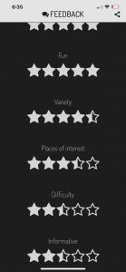
Audiences Feedback:

Audiences can rate my Quiz and give a feedback. It’s a two way communication.

Search can  be done,

You can search by area as well.

Week 5 LOCATIVE NARRATION IN DIGITAL CITIES

The notion of the public space will be associated with the dream like experiences of a city structure. In this context Berry has also stated that the presence of the different media platforms will be characterized by a transformation of the domain of public into the phase of publicness. The locative factor in the digital media is associated with the different mediums of time and space for the visual media like the television or the photography media.

Ritche in his analysis of the locative factor sin the digital media has proposed this analysis for the purpose of the establishment of the distance between the various ends visible in the Oxford Street. The bound was also created on the various computerized media. The bounds have also instructed that the user of this type of media in order to take the pictures of the underground station (Headrick 2-017).

According to Ritchie in the year 2014, there were several mobile forms of the locative nature of the narrative that will be navigated into the different spaces. The two spaces will be physical and the digital media forms. This principle will also apply to the various action bound apps because the various users will be compelled to accomplish the said mission. One of the main constraints that Ritchie has elaborated is the process of the possible inaccuracy that will occur if the user is bound to the various time bound manner when the users will be asked to form an effective evaluation of the time period to walk from the two ends of a single street.

In this context the various public space domains, the public space will be heavily dependent on the digital space perspective that will make users unable to accomplish the bounds. The locative networks will be based on the different technologies of the digital media that will turn into a relatively new phenomenon. The locative aspect of the digital media will also transform the +site-specific notions along with the other practices ((Sheller 2016).


References


Headrick Taylor, K., 2017. Learning along lines: Locative literacies for reading and writing the city. Journal of the Learning Sciences, 26(4), pp.533-574.

Sheller, M., 2016. Mobile mediality: Location, dislocation, augmentation. In New mobilities regimes in art and social sciences (pp. 335-352). Routledge.

Week 4 Digital Aspect of the Digital Cities

The concept of the digital cities is being developed all over the globe. Digital cities can integrate the urban information in both the achievable and the real time limits in order to create the different public spaces for the people to live in the cities. In the context of the urban space we can refer to the code space concept as given by Rob Kitchin and Martin Dodge. They mainly discussed about the computer code that ranges from the different digital mode of the control system that will create the new ways to undertake the various risks. The production of space as both of them has argued is the factor that is increasingly dependent on the various codes that will be required in order to produce the space concept (Ishida 2017).Dodge has also illustrated the idea of the different conceptual tools which will be required for the understanding of the various forms of interrelationships that will exist in the domain of space, software and in the context of the everyday life.

The concept of software in the digital aspect of the urban cities refers to the various animating functions that characterize a particular city through their various monitoring infrastructure that will regulate the flow contained in the different activities of the Daily life. The research regarding the various urban landscapes related to the concept of code will usually progress from their initial position of the non-representable form of the theory in which the different analytical lens that will relate to the ontological form of description. In this context of the city approach there will not be a fixed set of geometric and the hard objects in the city that will form the provisional objects that will take the digital form and the similar associated functions that will define the ways in which way they will be performed (Willis and Aurigi 2017).


References


Ishida, T., 2017, April. Digital city, smart city and beyond. In Proceedings of the 26th International Conference on World Wide Web Companion (pp. 1151-1152).

Willis, K.S. and Aurigi, A., 2017. Digital and smart cities. Routledge.


Week 4: Code/Space

According to “On the one hand, “public” can simply mean “outside the home” or “outside private space.”” (Berry et al., 2013, p.3). he was referring to Hannay (2005), the first definition of “Public” is the space out of the home or private space. Therefore, it is not only the squares or roads in the city, but also the space owned by the government but used by citizens, like bus stations or department stores. However, “public” is also defined as a political construction incorporated with liberty, which means all individual citizens can gather to have discussion about common issues. Hence, activities in public are often considered to be held face-to-face, like meetings or demonstrations.

Berry also says: Commuting, a task done by the laborer, has been both alleviated and interfered by modern technologies. Technological devices such as Ipads or mobile phones are considered “immaterial labor”, but “their manufacture belongs to a super-Fordist mode of production” (Berry et al., 2013, p.11). Imaterial labor is the labour that creates cultural value and in this term, there is a shortage of boundaries in laborers’ lives, as workers will eventually work on their own or spend a large amount of time thinking. This thinking time is hard to be measured and hence not paid for.

Code/space is the term pointing out the strong connection between software and spatiality. The former is produced to create the latter. This means “a dyadic relationship exists between code and spatiality” (Kitchin & Dodge, 2001, p.16). The illustration for code/space is an airport check-in counter, whose spatiality relies on software. If the code is broken down, the counter will no longer be a check-in area and become disorganised. Therefore, the space depends on the code. The same goes for supermarkets’ check-out areas, where computer systems play a vital role to decide the function of the space. Unless the code used for the system works properly, the counter cannot serve as a check-out space for customers. This means “the sociospatial production of the supermarket is functionally dependent on code” (Kitchin & Dodge, 2001, p.17).


References

Berry, C., Harbord, J. & Moore, R.O., 2013. Public space, media space, Basingstoke: Palgrave Macmillan

Kitchin, R. & Dodge, M., (2011). Code/space software and everyday life, Cambridge, Mass.: MIT Press

Week 4: Code/Space

When reading this case study, it seems there are many similarities between the characteristics of shipping containers and their uses, and software / computational code.

Shipping containers Code
Mid-century technology, originally used for military purposes, re-purposed to expand globalisation, commerce, and convenience Mid-century technology, originally used for military purposes, re-purposed to expand globalisation, commerce, and convenience
Changes the landscape of the towns and cities which use them for businesses e.g. Oakland, California Changes the landscape of the towns and cities which use them for businesses e.g. Silicon Valley, California
“Scalable solutions” for modern problems “Scalable” as one of Manovich’s five key characteristics of digital media
Used across multiple public services including, but not limited to, military, government, energy, healthcare, sanitation, food production, internet access Used across multiple public services including, but not limited to, military, government, energy, healthcare, sanitation, food production, internet access
Also used to cater for expanding social landscape which has emerged from our relationship with the space around us e.g. pop-up retail and bars Also used to cater for expanding social landscape which has emerged from our relationship with the space around us e.g. location-based dating apps
Cheap, accessible infrastructure for growing economies e.g. mobile internet cafes Cheap, accessible infrastructure for growing economies e.g. cheap smart phones enabling citizens to organise protests


Both have them have made lasting, measurable impacts to how people experience the space around them. They have brought the global to our doorstep, made it cheap and accessible. (Kitchin, Dodge, 2011:8) Their presence in our everyday lives has become ubiquitous, as when discussing code, known as everyware. (2011:9) Kitchin and Dodge explore how close the relationship is between code and space: “[they are] produced through one another” (2011:17) to the extent that once cannot be experienced without the other. (2011:16) It would not be too much to come to similar conclusions about shipping containers. So much of what we see, touch, smell, own, taste, and by extension how we experience the space around us, has come from a shipping container, to the extent that our societies would be unrecognisable were it not for the technologies that shaped it.


Berry, C., Harbord, J. & Moore, R. 2013. ‘Introduction’ Public space, media space. Basingstoke, Palgrave Macmillan pp 1-15.

Kitchin, R., Dodge, M. 2011. Code/space: Software in everyday life. Cambridge, MIT Press.

Morgan, S. ‘The plug and play city: how shipping containers are changing infrastructure’ The Conversation, 29th August 2016 < https://theconversation.com/the-plug-and-play-city-how-shipping-containers-are-changing-infrastructure-63125> accessed 24/02/2020.

Week 4 – Code/Space (Miriam Harvey)

Kitchin and Dodge (2011:20) describe their book Code/Space as being “about the relationship of software, space, and society”. The case study I chose this week (from http://www.scoop.it/t/the-programmable-city) is an article in Wired magazine about smart cars needing smart streets (Luke Dormehl, 2016) to communicate with and respond to each other to help their users. It is an example of code/space because Dormehl demonstrates in his article the relationship between cars, city and users.

Dormehl quotes Anthony Townsend to explain why traffic management is a problem that needs solving. Townsend describes the street as “a very complicated version of musical chairs”; a “scarce, expensive piece of land and resource” where “the more you co-ordinate it, the more benefits you can get.” He continues by pointing out that “30 per cent of traffic in cities is caused by people driving around looking for parking”.

The solution to this problem might be coming from a winning entry to a Smart City Challenge organised by the US Department of Transport, implemented by Alphabet-owned Sidewalk Labs. It involves “the use of camera-equipped vehicles […]  to count the number of available parking spaces in the city, as well as reading relevant parking signs [aggregated] with data from Google Maps [to] help direct drivers to empty spaces”. In this vision of the future, the code will be doing their “double duty” (Kitchin and Dodge, 2011:26) communicating in a machine-to-machine language between car and city, as well as in “an understandable notation for humans” such as a sat-nav image or an audio message in English to let the human car user know where to park their car.

Continuing on the theme of car/city communications, Dormehl refers to a recent data-sharing agreement between traffic app Waze and the city of Boston. The data that the city wanted from Waze is collected by the Waze app on car users’ mobile phones. This data is quietly collected through software that runs code to instruct the phone to collect GPS coordinates, calculate the speed and distance travelled, and capture use feedback. Kitchin and Dodge (2011:4) note that “although code in general is hidden, invisible inside the machine, it produces visible and tangible effect in the world”.

The ‘visible and tangible effects’ for Waze users is information that enables them to avoid traffic problems. The agreement between Waze and the city enhanced this service. Dormehl reports that “[i]n exchange for advance notice from city authorities about planned road closures, Waze agreed to share data gathered from its users with Boston’s traffic management centre”. The data collected from Waze users’ phones now had a wider, more long-term benefit as “this data exchange will help Boston to fine-tune its traffic light timings and urban planning.”

These two examples illustrate the point made by Kitchin and Dodge (2011:42) about the technicity of code where “software acts autonomously, and at various points in the process is able to automatically process inputs and to react accordingly”. However, they note that “technicity of code is not deterministic […] Rather, technicity is contingent, negotiated, and nuanced; realized through its practice by people in relation to historical and geographical context.” The software in smart cars and smart cities needs the human users to give it purpose. As illustrated in this artist’s impression from the 1950s of a future world with self-driving cars, the car journey is determined by humans while the car and the road work together to execute their pre-coded instructions.

1950s depiction of driverless cars

“A 1950s illustration depicting a utopian world of driverless cars. Photograph: GraphicaArtis/Getty Images”
Source: https://www.theguardian.com/technology/2019/oct/03/collision-course-pedestrian-deaths-rising-driverless-cars

The case study shows that there are new relationships emerging between public streets and the people, cars, technology services and city planners. Berry et al (2013:1) note a tension around the ownership of public spaces, stating that it “is almost by defini-tion contested, or at least negotiated, space in that no one person or company can unequivocally own and control it.” Maybe the notion of ‘pubic’ and ‘private’ should be reconsidered, as a smart city requires interdependence, and data to be collected, shared and used in a way that blurs the old boundaries between public and private.


References

Berry, C., Harbord, J. & Moore, R.O., 2013. Public space, media space, Basingstoke: Palgrave Macmillan

Dormehl, L. (2016). ‘The road to tomorrow: streets need to be as smart as the cars driving on them’. Wired. 7 November. Available from: https://www.wired.co.uk/article/smart-cars-need-smart-streets

Kitchin, R. & Dodge, M., (2011). Code/space software and everyday life, Cambridge, Mass.: MIT Press


Week 3: Data and the smart city: Critical perspectives

“There are few examples of progressive smart cities, but Barcelona’s recent reorientation of its smart city ambitions offers some pointers.” (Kitchin, R., 2019: 19)

A right-wing government allows Barcelona to be urbanized in a neoliberal approach. It implemented a wide range of smart city initiatives and it aims to bring smart cities around the world by SCEWC event. Nevertheless, there was a change in the approach to smart cities in May 2015. The purpose of this change is to make smart city campaigns focus more on citizens and promote participatory characteristic, which means that local people can use and own the technology. This is called “technological sovereignty”. According to Galdon, the source of technologies is committed to be open and there ought to be a guarantee for the residents to have access to it. Bria (2018) also emphasizes that citizens should have a close connection with technology and their rights need to be maintained.

“Cities cannot succeed in isolation.”  (P. 54)

This can be expressed by civic applications, data controlling or sensors done by the public instead of specific companies. In addition to this, Barcelona has tried to change the policy of the smart city to move the control and creation out of the private interests. Instead, it promotes the social development and civic movements. All of these endeavors including technological sovereignty illustrate the right decision in politics of the city.

To make cities develop and become successful, government need to ally with cities or political organizations to make sure that all devices or software can be used by the public rather than corporates. Therefore, there should be a participation of local companies or entrepreneurs in providing inventive services that protect the rights of workers and labor standards. This approach can enhance democracy and help to develop the economy in which laborers’ rights are ensured and long-term benefits are promoted. This is certainly not the only action that can be done, but it demonstrates how making a change in technological factors can develop the general welfare.


References:

Data and the smart city: Critical perspectives

A number of examples discuss what it means to be ‘ smarter ‘ on BBC Radio 4 Podcast in smart cities reveals the implications of the innovation approach for residents living in the smart city of Songdo. The BBC Radio 4 Podcast demonstrates that there have been many technological and infrastructure improvements to the city to make it “smarter “: more secure, sustainable for community and economically beneficial to citizens of that city.

The first example is that in Songdo is the implementation of a smart waste system that enables waste and waste trucks to be eliminated, with 76 percent of the waste being recycled.The waste system collects waste from the kitchens directly to a refinery.this approach can be seen as sustaining the environment and would probably help to keep the atmosphere clean and more desirable for tourist.


The other example is in Songdo was designed to track sensors ‘ temperature, energy consumption and traffic. Such sensors could alert you directly if your bus is overdue. And notify the local government of any possible problems.Therefore, the government could use these sensors to reliably view the environment and its major pollutants helping citizens to understand the nuances of air pollution in their everyday lives.Some people see this as a solution to a safety environmental.

Despite these key improvements and a range of initiatives over the last decade,Songdo is also a town under constant surveillance 500 cameras provide a complete grid coverage to monitor traffic or detect’ suspicious’ behaviour. Even the opening of the sewer cover is immediately notified to the IFEZ control centre in one of the towers in Songdo.It shows much of the government’s effect and implication. (Le Monde.fr, 2020)

According to (Miller, 2011p 24) The implication is that smart solutions based on traffic data collected in one place are unlikely to be universally applicable.That means not everyone is in agreement with the government’s way. Therefore, people will contradict on the way of smart cities will operate as being only beneficial.


Reference

BBC News. (2020). Has ‘smart’ Songdo been a success?. [online] Available at: http://www.bbc.co.uk/news/technology-23757738 [Accessed 17 Feb. 2020)

Le Monde.fr. (2020). Songdo, ghetto for the affluent. [online] Available at: https://www.lemonde.fr/smart-cities/article/2017/05/29/songdo-ghetto-for-the-affluent_5135650_4811534.html [Accessed 17 Feb. 2020].

Miller, V. (2011) ‘Understanding Digital Culture’ Key Elements of Digital Media London,Sage publications. pp 24