Week 10 – Sustainability, Mobility, Utopia and Sensing Cities

When the society is developed, there is a growth in mobility system. According to Elliott & Urry (2010), in today’s society, people are connected with each other not only through constant mobility and face-to-face encounters, but also via travelling messages and objects. The societies can cope with distance thanks to different processes, two of which are virtual travel and communicative travel via letters, texts or telephones. This is how the society deals with social-distancing solution due to COVID-19 pandemic. The disease forces people to cut down on face-to-face interaction as much as possible to halt the spread. “The investment of affect into virtual objects (eg Facebook, Skype, etc) comprises a part of a “containment of anxiety’, which comes to the fore in conditions of complex mobile and digital life” (Elliott & Urry, 2010, p.21). Thanks to technology, people can deal with the social-distancing campaign.

Elliott and Urry (2010) suggest that one of the future scenarios is the emergence of hypermobility, which means there will be a significant development in mobile lives thanks to new transportation and communication practices. Telepresencing will become ubiquitous as it allows interactions to occur across different areas effortlessly. This concurs with the situation in the Covid-19 pandemic. Obviously, people still have a high demand of meeting each other in person as meeting online never replaces real-life interaction, but the dangerous level of the disease does not allow people to easily make any face-to-face appointments. Therefore, technology will be developed to meet people’s demand. For example, tele-immersion environments enable users to work or interact with each other in a shared and simulated environments. According to Elliott and Urry (2010:150), “the shock of climate change may tip societies into these kinds of digital network and a post-car future”.


References

Elliott, A., & Urry, J. (2010). Mobile lives. Routledge.

Week 9 – Drones

“Drones” is the term that some experts refrain from using as it connotes the meaning of killing from distance in the war of western areas. In this case we want to regard “drones” as “a new dimension of real-time surveillance information in the contemporary city on a more general level” (Jensen, 2016, p.68). However, the ethical problems associated with drone technology do not disappear thanks to our effort to domesticate or naturalize the term in the peaceful era. In other places, Foucault (2003) suggests that this can be considered western government’s techniques and their testing in foreign areas, which is then brought back to domestic areas. There are many political and ethical issues related to drone technologies as there are some controversies around civil rights and privacy when drones are utilized in public. Obviously, using drones as surveillance can save a huge amount of money and can serve humanitarian purposes, like providing assistance in disaster zones. Nevertheless, when thinking about the situations where drones are officially used for city surveillance, there are some cautions arising. To create the flying path for drones, we need to organize and control the air traffic like what we do with airplanes. This can cause some issues, one of which is safety as drones can crash each other. Another concern is privacy. Although NoFly-Zone company has brought about the system that can make the drones not fly to restricted areas, the system can be hacked, as a drone is just a flying computer (Goodman, 2013). The case study of Mitchell Sipus (2014) has explored the three-dimension understanding of urban areas. Specifically, it is necessary to perceive cities in both two-dimension and three-dimension ways, as the volumes and voids in-between the buildings require planners to imagine the space. The appearance of drone surveillance activates a rethinking of urban areas and mobile circumstances.

References

Foucault, M., & Ewald, F. (2003). ” Society Must Be Defended”: Lectures at the Collège de France, 1975-1976 (Vol. 1). Macmillan.

Goodman, M. (2013). A view from the unfriendly skies: How criminals are using drones. TED. com.

Jensen, O. B. (2016). Drone city-power, design and aerial mobility in the age of” smart cities”. Geographica Helvetica71(2), 67.

Sipus, M. (2014). Zoning and Urban land use planning for drones, available at: http://www.thehumanitarianspace.com/2014/08/ zoning-and-urban-land-use-planning-for.html

Week 8: Digital Urban Gaming

I’ve interviewed my friend about his experience when playing Pokemon Go. He said that “When playing this game, I naturally do more exercise by walking around and be more aware of my surrounding. Sometimes, thanks to Pokemon Go, I know the places in my area that I haven’t noticed before”. Foth and Gifford (2016)

(Foth, Hudson-Smith, Gifford, 2016: P.20)

(Foth, Hudson-Smith, Gifford, 2016: P.20)

(Foth, Hudson-Smith, Gifford, 2016: P.20) believe that Preliminal games aims to promote a platform that make players more motivated to reconnect with their surroundings and activate their exploration about the parts of environment where they may not have visited. This kind of game brings about some supplementary factors via associating the city’s streets with environment built virtually, which allows players to have new experiences when discovering these spaces. Importantly, the places are not replaced by the new ones. Instead, it just augment the space so that the users can experience something new in their existing surrounding. Thanks to their interaction with the locations in reality, the player appreciate their landscape more.

My friend also shared that the time restriction in the game makes him more engaged and try hard to gain the items in the limited period of time. According to Foth and Gifford (2016), this use of constraint make the game more engaging and challenging. They conclude the benefits of this game is that it not only helps players to do exercise and connect with the social space, but also helps local enterprises to have more customers thanks to the boosted footfall.

However, my friend said that sometimes he was too focused on playing the game and therefore neglected his real social interaction. “Pokémon GO recalls issues relating to mobility, sociability, spatiality, and surveillance that are characteristic of many previous hybrid reality games and mobile location-based applications.” This concurs with the belief of Hjorth (2017, P.5), who suggests that Pokemon GO can be used to allow players to avoid engagement with other people in public places. Furthermore, there are also some dangers in terms of information about location. This can enables the robbers to know exactly the location of people to commit the crime.


References:

Foth, M., Hudson-Smith, A. & Gifford, D., 2016. Smart cities, social capital, and citizens at play: A critique and a way forward. In Research Handbook on Digital Transformations. Cheltenham,: Edward Elgar Publishing, pp. 203–221.

Hjorth, L. & Richardson, I., 2017. Pokémon GO : Mobile media play, place-making, and the digital wayfarer. Mobile Media & Communication, 5(1), pp.3–14.

Week 6: City Dashboards and Open Data

According to Kitchin et al. (2015, p. 12), “the power of indicators, benchmarking and dashboards is that they reveal in detail and very clearly the state of play of cities.” Thanks to this power, people can get to know their city by the visualization and analysis made from the data. Indicators can be used to track the change of specific phenomenon. They are usually integrated with another index to provide the view for the whole contexts. In terms of cities, indicators serve as an instrument to gauge the cities’ performance. This is often illustrated by the charts of maps and can provide some forecast for the future trend. The indicator data is very helpful for the bodies to monitor and evaluate the efficiency of urban services and policy. This can also supports them to manage and govern the cities. There are two approaches for the cities to use these kinds of data. The first one is that they promote democracy and accountability and the second is that they enforce regulation to develop effectiveness.

The agenda generated by United Nations Conference on Environment and Development (UNCED) has pointed out that the indicators of sustainable development should be fostered for the officials to reach wise decision in terms of protecting environment and promoting economic at the same time. Following this, city officials and citizens’ community should figure out and invent the indicator data that suffice the needs of their areas.

Data analysis is involved in 11 fields of activities run by local officials. One area is for opening government, which means data is made to be transparent for those who require Freedom of Information policy in the North of England. Another field supported by data analytics is the transformation of public service in Newcastle. Thanks to this, social workers can keep track of the changes in children’s social care services and cope with complicated family needs in a better way. Beside this, “Leeds’s Innovation Labs provide a space for local developers to experiment with open data sets to solve social problems, and develop viable new products and services.” (Symons, 2016, p.7)


References:


Brighton & Hove City Council. ‘Brighton & Hove Community Insight’ <https://brighton-hove.communityinsight.org/map/>

Kitchin, R. Lauriault, T. & McArdle, G. 2015. ‘Knowing and governing cities through urban indicators, city benchmarking and real-time dashboards’ Regional Studies, Regional Science, vol 2 issue 1, pp 6-28.

Symons, T. 2016. Wise Council: Insights from the cutting-edge of data-driven local government. London, Local Government Association.


You This image requires alt text, but the alt text is currently blank. Either add alt text or mark the image as decorative.This image requires alt text, but the alt text is currently blank. Either add alt text or mark the image as decorative.This image requires alt text, but the alt text is currently blank. Either add alt text or mark the image as decorative.

Week 5 – Locative Narrative + Actionbound

The possibility of story-telling through media relies on how the media are used for expressing the stories and how it is constrained. According to Ritchie (2013, p.65), “mobile locative narratives only come into being through the decisions and efforts of audiences.” It means that audiences need to have the navigation in both physical and digital spaces to determine the factors related to the story. By this way they can achieve understanding and can even co-author a story. This requires significant effort. Therefore, to bring about these interactions, it is a duty of mobile locative narratives to give the audiences the medium for seeking information and narrative bridges. In this sense, the transfer between physical and digital can be considered the strain between these kinds of narratives. They provide descriptions and explanations to each other, which means that the location or objects that are mediated digitally are constricted and defined through “an implicit or explicit act of chronologically or causally creating a sequence of events” (Ritchie, 2013, p.65). In conclusion, there is a control over the chronological possibility of constructed and digital settings if one narrative or varied narratives are enforced on the other.

Hochman and Manovich (2013) has conducted a research to examine the living experience of people who use media sharing software and the way visual social media demonstrate the lives of a community or each person. It also sheds light on the elements that this data cannot resonate. The results reveal the conceptual cultural change in how people recognize and use the cultural information on the Internet. Lately, cultural software devices, in our case like actionbound (in this article it was talking about Instagram), do not put much emphasis on arranging information into specific types or structures. Alternately, they allow users to discover and explore the data in both spatial and temporal dimension. For instance, social networking sites like actionbound (or Instagram as mentioned in the article) enable users to find images by utilizing hashtags, sites, or by following other users, instead of just use hierarchical subject genres.


References:

  • Hochman, N. & Manovich, L., 2013. Zooming into an Instagram City: Reading the local through social media. First Monday, 18(7). Available at: http://firstmonday.org/ojs/in- dex.php/fm/article/view/4711
  • Ritchie, J. 2014. The Affordances and Contraints of Mobile Locative Narratives. In The Mo- bile Story. Narrative Practices with Locative Technologies, ed. J. Farman, 53–67. Oxon: Routledge.
Creating my own quiz on actionbound.

My Quiz on actionbound,
I was able to upload a short film from my phone to publish this quiz.

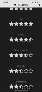
Audiences Feedback:

Audiences can rate my Quiz and give a feedback. It’s a two way communication.

Search can  be done,

You can search by area as well.

Week 4: Code/Space

According to “On the one hand, “public” can simply mean “outside the home” or “outside private space.”” (Berry et al., 2013, p.3). he was referring to Hannay (2005), the first definition of “Public” is the space out of the home or private space. Therefore, it is not only the squares or roads in the city, but also the space owned by the government but used by citizens, like bus stations or department stores. However, “public” is also defined as a political construction incorporated with liberty, which means all individual citizens can gather to have discussion about common issues. Hence, activities in public are often considered to be held face-to-face, like meetings or demonstrations.

Berry also says: Commuting, a task done by the laborer, has been both alleviated and interfered by modern technologies. Technological devices such as Ipads or mobile phones are considered “immaterial labor”, but “their manufacture belongs to a super-Fordist mode of production” (Berry et al., 2013, p.11). Imaterial labor is the labour that creates cultural value and in this term, there is a shortage of boundaries in laborers’ lives, as workers will eventually work on their own or spend a large amount of time thinking. This thinking time is hard to be measured and hence not paid for.

Code/space is the term pointing out the strong connection between software and spatiality. The former is produced to create the latter. This means “a dyadic relationship exists between code and spatiality” (Kitchin & Dodge, 2001, p.16). The illustration for code/space is an airport check-in counter, whose spatiality relies on software. If the code is broken down, the counter will no longer be a check-in area and become disorganised. Therefore, the space depends on the code. The same goes for supermarkets’ check-out areas, where computer systems play a vital role to decide the function of the space. Unless the code used for the system works properly, the counter cannot serve as a check-out space for customers. This means “the sociospatial production of the supermarket is functionally dependent on code” (Kitchin & Dodge, 2001, p.17).


References

Berry, C., Harbord, J. & Moore, R.O., 2013. Public space, media space, Basingstoke: Palgrave Macmillan

Kitchin, R. & Dodge, M., (2011). Code/space software and everyday life, Cambridge, Mass.: MIT Press

Week 3: Data and the smart city: Critical perspectives

“There are few examples of progressive smart cities, but Barcelona’s recent reorientation of its smart city ambitions offers some pointers.” (Kitchin, R., 2019: 19)

A right-wing government allows Barcelona to be urbanized in a neoliberal approach. It implemented a wide range of smart city initiatives and it aims to bring smart cities around the world by SCEWC event. Nevertheless, there was a change in the approach to smart cities in May 2015. The purpose of this change is to make smart city campaigns focus more on citizens and promote participatory characteristic, which means that local people can use and own the technology. This is called “technological sovereignty”. According to Galdon, the source of technologies is committed to be open and there ought to be a guarantee for the residents to have access to it. Bria (2018) also emphasizes that citizens should have a close connection with technology and their rights need to be maintained.

“Cities cannot succeed in isolation.”  (P. 54)

This can be expressed by civic applications, data controlling or sensors done by the public instead of specific companies. In addition to this, Barcelona has tried to change the policy of the smart city to move the control and creation out of the private interests. Instead, it promotes the social development and civic movements. All of these endeavors including technological sovereignty illustrate the right decision in politics of the city.

To make cities develop and become successful, government need to ally with cities or political organizations to make sure that all devices or software can be used by the public rather than corporates. Therefore, there should be a participation of local companies or entrepreneurs in providing inventive services that protect the rights of workers and labor standards. This approach can enhance democracy and help to develop the economy in which laborers’ rights are ensured and long-term benefits are promoted. This is certainly not the only action that can be done, but it demonstrates how making a change in technological factors can develop the general welfare.


References:

Week 2: Smart Cities and Digital Culture

In the BBC Radio 4 Thinking Allowed podcast on smart cities, a discussion on what it means for a city to be ‘smart’ is examined through multiple examples. To guide our discussion, we will use the definition of smart cities as set out by Townsend as “places where information technology is combined with infrastructure, architecture, everyday objects, even our bodies to address social economic and environmental problems” (Townsend, 2013: 15), though this definition does have its limitations.


One example explored in the podcast is the traffic in Calcutta; here the infrastructure cannot reliably handle the volume of traffic in the city. (Taylor, 2018) A ‘smart’ solution to such a problem will differ based one the very urban environment in which it is occurring. Miller points out that we have increasingly moved toward a world where information is stored in non-narrative and decentralized databases. The advantage is that theoretically the information contained in these databases can be endlessly reconfigured and reinterpreted, as they are consistent of units of information that variable and constantly transforming, as opposed to information stored in “old media” (Miller,2011: 14).


However, this aspect of the digital age also brings with it its drawbacks. As Miller points out, reducing and reconfiguring information into a digital space, ultimately means that context surrounding that very information is lost. As Miller puts it “where a narrative would provide a context, a cause, a reason, or a story, a database provides a temporary relationship.” (Miller, 2011: 24) The implication being that smart solutions based on traffic data gathered in one place, are unlikely to be applicable universally.


In the podcast it is pointed out that Calcutta’s traffic situation would be more easily remedied by a better public mass transport system, whereas solutions that are often hailed as ‘smart’, like driverless cars, might be a better solution for congestion and pollution in other cities. This illustrates that there is more to a city being smart than just gathering and processing information, it is ultimately also dependent on where and by who the increased information is processed.

This can also be seen in the example of noise pollution on one busy street in Barcelona. Here local residents campaigned to reduce local nighttime hubbub. It was not until they banded together and created a network of low-cost sensors that fed back-on and quantified the problem that they were able to enact change. Through this network they proved that the sound reached “well above UN guidelines.” (Taylor, 2018) It was there very ability to amass and interpret information that brought about substantive social change.


This does raise an issue that might impact a city’s ability to become ‘smart’. As Townsend puts it for cities to become truly smart a “new civics” will be needed, “we need to take back the wheel from the engineers and let people and communities decide where to steer.” (Townsend, 2013: 14) The residents in this example had the means, technology and infrastructure to put the requisite sensors in place – but this is not going to be an option for every community. Socio-economic factors and access to developing technologies are always going to impact on how we can interact with a smart world. No surprise then that Townsend opts to focus on “what do you want a smart city to be?” (Townsend, 2013: 15), rather than what it is.


References:


Miller, V. (2011) ‘Understanding Digital Culture’ Key Elements of Digital Media London, Sage publications. pp 12-21.

Taylor, L. (2018) ‘Smart Cities’ Thinking Allowed podcast 25th July 2018. BBC Sounds accessed 10/02/2020: https://www.bbc.co.uk/sounds/play/b0bbr3zn

Townsend, A.M., (2013) ‘Smart Cities’, New York: W. W. Norton & Company. xi-18.