About James Branch

Studying an MRes in Arts and Cultural Research at Brighton and blogging about digital cities and design

Printed Houses

Screen Shot 2014-05-13 at 00.57.34Screen Shot 2014-05-13 at 00.57.51

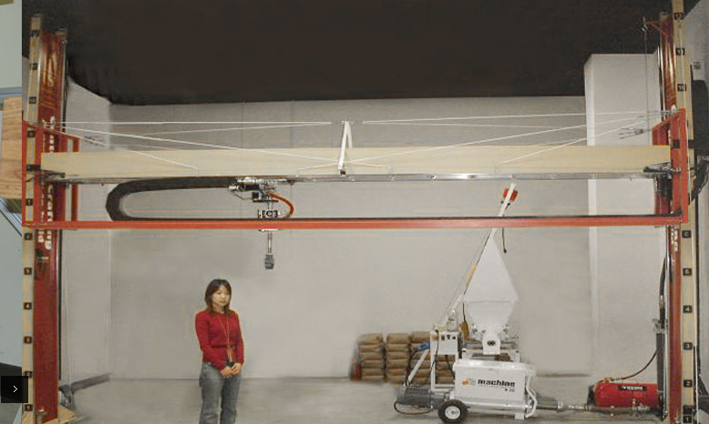
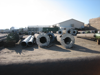
One of the promises of 3-D printing discussed by Lipson and Kurman (2013, p.15) is that it will bring qualities associated with digital information to the physical world. They argue that by precisely controlling the material composition of physical objects, materials can be potentially be readily copied, controlled and programmed. This is, in part, made possible because unlike traditional methods for making physical objects that rely on either using moulds or cutting away at raw materials, 3-D printing is described as additive or layered manufacturing process in which layers of material are precisely poured to create structures following instructions from a design file (Lipson and Kurman, 2013, p.13). An example of a project that uses this a variant of this technology is Contour Crafting (CC) — a concept for an automated construction system developed by the USC Center for Rapid Automated Fabrication Technologies (CRAFT). The project is described as having the potential to relatively quickly fabricate or 3-D print buildings, with vast improvements in safety and a reduction in waste compared with traditional methods. In this respect the topic of 3-D printing seems to share some of the features of much of the discussion around Smart or Digital Cities, with a strong conviction from advocates that automation and efficiency is the best way to meet the challenges faced by the construction industry, which is described as facing several problems including; “low productivity, poor quality, low safety, and skilled labour shortage” (Khoshnevis et al, 2006, p,305). It is definitely hard to argue with the logic of the CC project when one reads the case studies that outline the possibilities for emergency housing and low income housing, but an issue that is also shared with the Smart/Digital City has to be a concern for what this means for the labour force. In this example it does seem to be the case that the safety of the system is largely achieved by eliminating the need for many humans to be involved in the process.

Khoshnevis, B., Hwang, D., Yao, K. and Yeh, Z., 2006. Mega-scale Fabrication by Contour Crafting. International Journal Industrial and Systems Engineering, [online] Available at: <http://www.livearchitecture.net/wp-content/uploads/2010/01/khoshnevis_mega-scale-fabrication.pdf> [Accessed 10 May 2014].

Lipson, H. and Kurman, M., 2013. Fabricated: The New World of 3-D Printing. Wiley: New York.

Links:

Video interview with CC inventor Dr. Khoshnevis
http://youtu.be/ypZ37tm-BBI

Race to build first 3-D printed building
http://www.wired.co.uk/news/archive/2013-06/04/architecture-and-3d-printing

Press reports on the CC project
http://www.huffingtonpost.com/2014/01/21/3d-printer-house-mars-slums_n_4639046.html
http://dailytrojan.com/2014/01/16/viterbi-refines-3-d-printer/

Image source: http://www.contourcrafting.org/

Sensors and sensing

Elliot and Urry (2010) outline a digital networks future as a course of action that could be undertaken to address the challenges posed by climate change, increasing populations and energy descent (Elliot and Urry 2010, p.138). It is a post-crisis or post-shock response comprising of a suite of products and services produced by ‘low carbon’ corporations aimed achieving sustainability. In this context much of what we do, including how we get around or movement in the city is optimised and integrated into a network system enabled by a slew of sensors and technology that do everything from navigation to payment collection (Elliot and Urry 2010, p.147). Andrejevic and Burdon (2015) call this the “sensor society” and they argue that this is not a future prospect, but a world we are already living within. Taking the examples of a smart phone and web browser, they argue that the interactive devices and applications that populate our digital information environment also double as sensors — sensors being anything that automatically captures and records data that can then be transmitted, stored, and analysed. (Andrejevic and Burdon, 2014, p.7)

Drawing on Wood et al (2006) Andrejevic and Burdon (2014, p.5)  argue that the sensor society “reconfigures received categories of privacy, surveillance and sense-making” because unlike traditional forms of surveillance, which may be focused on identifiable persons, the goal of sensor-based forms of surveillance is much more of a comprehensive capture of data about a particular population or environment, from which, more systematic forms of targeting occur (Andrejevic and Burdon, 2014, p.5). This is described as the monitoring of “dimensions of a population, environment or ecosystem or registers of activity” for comparison and for the identification of patterns. Returning to Elliot and Urry’s (2010) digital networks future the pervasiveness of sensing and sensors (both obvious and as a byproduct of our interactions) may well be a useful tool in terms of sustainability, however because (amongst other attributes) data is, as Powell (2014) describes it, “indeterminate” and what it reveals can change depending on how different dimensions are brought together. It is the case that we will increasingly find it difficult to comprehend or predict what our data might reveal about us. (Andrejevic and Burdon, 2014, p16).

Andrejevic, M., and Burdon, M., 2014. Defining the Sensor Society. [online] Available at: <http://cccs.uq.edu.au/sensor-society> [Accessed 3 May 2014].

Elliot, A., and Urry, J., 2010. Mobile Lives. Routledge: Oxon.

Powell, A., 2014. Making data bleed, [Lecture to Information Experience Design symposium]. Royal College of Art. 5 May 2014.

Links:

Image source: http://www.engadget.com/2014/01/07/intel-smart-baby-onesie/

Invisible Cities – visualisation of geo-social data: https://www.schemadesign.com/invisiblecities/

Detection devices: how a ‘sensor society’ quietly takes over
http://theconversation.com/detection-devices-how-a-sensor-society-quietly-takes-over-26089

Human Microchips
http://media.theage.com.au/technology/tech-talk/human-microchips-5354618.html

Affective computing
http://affect.media.mit.edu/projects.phphttp://edition.cnn.com/2014/02/04/tech/innovation/this-new-tech-can-detect-your-mood/index.html

Smart Citizen – environmental monitoring kit

Screen Shot 2014-04-29 at 10.13.27Screen Shot 2014-04-29 at 10.13.33

Marshall (1950) defines citizenship as being composed of civic, political and social elements, which as Sassen (2002, p.7) describes, form a legal status entailing “the specifics of whom the state recognizes as a citizen and the formal basis for the rights and responsibilities of the individual in relation to the state”. Recently Sassen (2008) has identified what she calls a certain “denationalizing” transformation in the institution of citizenship that occurs as a result of changes in the territorial and institutional organization of state authority and globalization (Sassen, 2008, p.7). In other words, as the conditions in which citizenship is embedded change, so does the institution itself. Sassen (2008, p.281) suggests that the global city is a key driver of this change, a “partly denationalized space that enables a partial reinvention of citizenship as a practice and a project”. In place of questions of nationality the practices and informal politics of citizenship can move toward the enactments of a large array of particular interests or “rights to the city”.

In this context, one particular interest or civil rights issue that a many citizens living in cities face is air pollution, which is the focus of the Smart Citizen environmental monitoring project (Fab Lab Barcelona, Institute for Advanced Architecture of Catalonia). The Smart Citizen kit is an open-source environmental monitoring platform consisting of arduino-compatible hardware, a data visualization web API, and mobile app to measure localised environmental pollution (CO, NO², temperature, humidity, light intensity and noise levels) (Waag, 2014). The citizen or perhaps Smart Citizen in this project is potentially able to contest traditional sources of environmental data and by sharing information online gain wider global support for a local issue. Aligning with Sassen’s (2008) critique, this project certainly taps into a contemporary version of citizenship, that identifies with a particular issue and asks questions of citizenship’s traditional national boundaries. The challenge for the project is to remove the boundaries in terms of cost and technological proficiency that may stand in the way of making this a democratic endeavour.

Marshall, T., 1950. Citizenship and Social Class. In: J. Manza. and Sauder, M. ed. 2008.  Inequality and Society. W.W. Norton and Co.: New york.

Sassen, S., 2002. The Repositioning of Citizenship: Emergent Subjects and Spaces for Politics. Berkeley Journal of Sociology, [online] Available at: <http://transnationalism.uchicago.edu/RepositioningCitizenship.pdf> [Accessed 27 April 2014].

Sassen, S., 2008. Territory, Authority, Rights: From Medieval to Global Assemblages. New Jersey: Princeton University Press.

WAAG Society, 2014. Projects: Smart Citizen Kit. [online] Available at: <https://waag.org/en/project/smart-citizen-kit> [Accessed 27 April 2014].

Image source: http://waag.org/en/project/smart-citizen-kit

Links:
Press reports of the project:
http://techcrunch.com/2013/05/19/acrobotics-wants-to-kickstart-smarter-cities-with-its-smart-citizen-environment-sensors/
http://www.newscientist.com/article/dn25393-a-smart-way-to-get-personal-with-the-future.html#.U1pizsc2w4M

More about the project from an initial trial in Holland:
https://waag.org/en/blog/smart-citizens-waag
https://waag.org/en/project/smart-citizen-kit

Interview with Saskia Sassen discussing contemporary citizenship:
http://citsee.eu/interview/%E2%80%98artisans-incorporation%E2%80%99-interview-saskia-sassen

Press report about contested air pollution data in Beijing:
http://blogs.wsj.com/chinarealtime/2014/04/14/beijings-bad-air-days-finally-counted/

What is a Smart Citizen?Hill, D,. 2013. Smart Citizens Make Smart Cities. In: Hemment, D. & Townsend, A., 2013. Future Everything publications: Smart Citizens. Available at: <http://futureeverything.org/publications/smart-citizens/ > [Accessed 27 April 2014].

Future Everything 2014

IMAG2143 IMAG2147 IMAG2151

Smug post from the festival… The event definitely seems to be an intersection for different visions of digital cities that we’ve talked about. You can see how large tech companies like Intel are connecting with the event and putting funding into ‘smart city’ projects such as Smart Citizen – a research project aimed at providing people with cheap air pollution monitoring kits to gather huge amounts of data on air quality. At the other end of the spectrum there are some really interesting bottom up initiatives for example Rachel Raynes artist in residence at Raspberry Pi was really inspiring as was the Zuolark’s El Campo de Cebad public space project in Madrid.

Download a list of people, projects and references that caught my attention during the conference here Future_Everything_2014


Urban gaming precedents

In looking for historical analogies for contemporary forms of mobile based urban gaming both Hjorth (2011) and de Souza e Silva and Sutko (2009) reference the flâneur. The flâneur is a caricature or trope used by several authors from Baudelaire to Benjamin. He is described as embodying a blasé attitude — a wanderer through the 19th Century boulevards of Paris that sees the city as visual spectacle (de Souza e Silva and Sutko, 2009). In the sense that the flâneur re-appropriates the city space of work, routine and purposeful activity with random walks, a parallel can be drawn with the Situationist International subversive activity of dérive. As a challenge to what Guy Debord perceived as the increasing commercialization of everyday life in 1960’s Paris, dérive is described by Hjorth (2011) as a strategy of drifting through geographic space. An experimental behavior that radically revises usual motives, actions or traditional routine ways of being in the city.

Holly Gramazio speaking at today’s Future Everything conference described a less well known urban gaming precedent — the treasure hunts organized by local London newspapers at the beginning of the 20th Century. In an attempt to increase circulation, newspapers such as Dispatch, created national treasure hunt competitions, with cash prizes for those able to follow the weekly clues to locate concealed medallions. In response to complaints about damage to property and violence that occurred as crowds congregated on specific sites to dig for the buried medallions, Earl Desart (Director of Public Prosecutions) wrote to the proprietors of certain newspapers and the competitions were eventually halted.

Certainly in the case of the texts by Hjorth (2011) and de Souza e Silva and Sutko (2009) the  the flâneur and dérive strategies seem to be important jumping off points for thinking about cities in relation to gaming. But, hearing Gramazio speak today about the treasure hunt riots, made me question whether there are less well covered genealogies of urban gaming that could be further explored, to help us better understand contemporary urban gaming practices and effects.

de Souza e Silva, A., and Sutko, D., (2009). Merging Digital and Urban Playspaces. In: de Souza e Silva, A., and Sutko, D., (2009). Digital Cityscapes Merging Digital and Urban Playspaces. New York: Peter Lang Publishing. Ch.1

Hjorth, L. (2011). Mobile@game cultures: The place of urban mobile gaming. Convergence, 17(4), 357-371.

The treasure hunt riots that Holly Gramazio’s referenced in her talk at Future Everything today are covered in detail on this website:http://www.planetslade.com/treasure-hunt-riots1.html

Listening to Location

Motte-Haber (1998 cited in Behrendt, 2012, p.287) points out that the “geometric description of space enforces the visual dominance of space reception”. In other words, because we can readily measure space, this makes it easier to communicate and render precisely via visual means — space then gets defined as a visual phenomena at the expense of non-visual aspects of spatial perception such as sound. Side stepping the visual bias to consider spaces sonically, foregrounds the importance of time, because without time you have no sound. This move allows for a temporal analysis of spaces or media and spaces. In such an analysis, spaces have to be considered as less bounded, with permeable boundaries unlike the “hard and fast visual constructions of space” (Behrendt, 2012, p.288). As this description of the Soho Stories locative sound app concurs; “If you move away from an area the audio fades rather than cuts out. As you move back it picks up where you left off” (Telegraph, 2012). The fade here drawing attention to the ephemerality of sound and in turn its temporality.

Considering the temporal dimension to an analysis of locative media does some good things. Firstly, it diminishes the importance of the “common focus on location” (Behrendt, 2012, p.292), when you add a temporal dimension locations become more like events. Thinking of an event, you no longer consider the body as static, instead you start to think of movement or performances or “embodied interactions” (Behrendt, 2012, p.292). The immersion in space that a sonic encounter with the world entails, also puts us, or the user, in the middle — “centre stage” (Behrendt, 2012, p.292). So one’s “situated experience” and the framing social, physical context is given primacy. This way of understanding how people, media and space work together in time is shared by Mackenzie (2003, cited in Timeto, 2013) who uses the concept of transduction. The theory is complex and multi-facted, but to take a brief quote, he describes how he considers technologies as “events happening together with people encountering their affordances on the basis of situated practices”. In this way a sonic perspective allows for analysis of locative media to find people, material places and practice in location, again.

Behrendt, F. (2012) The Sound of Locative Media. Convergence: The International Journal of research into New Media Technologies, 18(3): 283-295.

Telegraph., (2012). Soho Stories Android app review. [online] Available at: <http://www.telegraph.co.uk/technology/mobile-app-reviews/9555035/Soho-Stories-Android-app-review.html> [Accessed 24 March 2014].

Timeto, F., (2013). Redefining the city through social software: Two examples of open source locative art in Italian urban space. First Monday, [online] Available at:< http://firstmonday.org/ojs/index.php/fm/issue/view/405> [Accessed 16 Dec 2013].


AR Testing


Test 1 on 2-D printed material. Traffic sound mp3 file and a German map.
Software works well with small .mp3 file size and the graphic nature of this image.


Test 2 on 3-D object. Environment Agency Twitter feed and a water cooler.
I was quite surprised that the software recognised the watercooler as the shapes are not hugely distinctive. The process of acquiring the information via WiFi necessary to render the Twitter feed took quite a long time.

Test 3 on 3-D organic object. Plant care website and my cheese plant.
The software really didn’t like the Cheese plant. The curved organic forms really seems to fox the algorithm, but it did eventually recognise the form and load a website.

As a user of Augmented Reality software I did feel affected when I aligned reality correctly with the device and the software recognized the features of the scene to deliver the sound, video or image. Karppi (2011) in describing this moment, or as he calls it — event, uses three layers as a method of analysis; the first layer is relations between the real environment and the application, the second is the interface or browser screen and the third is the user and the software. In the first layer the application puts the invisible chaotic environment full of data in order via the processes of “seeing, articulating and calculating”. In the second layer, the interface mediates us an environment – we move our bodies to to reveal not a static image but a “mobile temporal section of the world”. In the third layer, Karppi (2011) draws on Parisi and Terranova to suggest that we should try to understand these ‘events’ outside questions of representation and reality. Instead we are to think of these events as affective media, with the capacity to “embody the experience of seeing without deceiving the spectator or falling into the category of unreal simulations”.

I’d like to follow this post up and expand on this as I think some of the ways that Karppi is describing affective images chimes with a little of what I’ve read of Flusser’s (2011) account of technical images but this is all I’ve got for now!!

Karppi, T. (2011) Reality Bites: Subjects of Augmented Reality Applications. In Unfolding Media Studies, eds. Puro, J. and Sihvonen, J. Turku: University of Turku: 89-102 Karppi(2011) Reality Bites- Subjects of Augmented Reality Applications.pdf

Net Localities

Gordon and De Souza e Silva’s (2011) use the term Net Localities to describe a meeting of digital information and the city. They are interested in what happens to institutions, communities and places when networked data floods into physical spaces (p.13) principally via our mobile devices. Net Locality for them is “a ubiquity of networked information” (p.3) in other words, access to a global network of information while situated in a local street. As such, Net Locality means a change in how we experience scale, something they later describe as a thinning of the distinction between nearness and distancelessness. Net Locality is also shift toward the ordering of data by location, in short, “the organisational logic of the web is based on physical location” and “…the types of information we find and access online depend on where we are”. In addition to these factors the locational affordances of mobile devices mean that “virtually everything and everyone is located or locatable”, so Net Locality is also about what happens to individuals and society in that context.

If Net Localities describes a place in which there has been a shift from a world in which there was a clear distinction between atoms and bits (Negroponte ,1995) to one in which “the world we live in and the web can no longer be so easily separated”. (p.1) Having used a location based app this week I find this move toward a seamless blurring of boundaries between digital information and location contrasts with my experience, which was quite seam-full. Having first attempted to “Check In” on arrival at my Mum’s house, I found that my Mum’s house is not yet a Place. I needed to “Add this place to check in here”. I was required to type in the name and address and save these details so that in future my Mum’s house would be visible in the App. Bingham-Hall (2013) also has his doubts about conflating information and space as his an account of using a laptop in a public space in Kings Cross outlines; “… if someone were to ask me where I’ve been and what it was like I would surely describe the observable three-dimensional space of Granary Square. If I told them I’d been ‘in/at Facebook’ or ‘everywhere at once’ I’d be seen as having misunderstood the experience of communicating online.” He suggests we need to aim for “a much more nuanced and tempered understanding of the coming together of digital and urban that is based in, and can therefore help to shape, reality.” (Bingham-Hall, 2013)

Bingham-Hall, J,. (2013). On the Search for Space in the Digital City a Dispatch from Granary Square. Urban Pamphleteer, [online] Available at: < http://www.ucl.ac.uk/urbanlab/docs/Urbanpamphleteer_1> [Accessed 13 Dec 2013].

Gordon, E,. and de Souza e Silva., (2011). Net locality: why location matters in a networked world, Chichester: Wiley-Blackwell.

Thin and thick trust is a really interesting aspect of Gordon and de Souza e Silva’s text  and chimes with Kio Stark’s Stranger Studies 101 (2010):
http://www.theatlantic.com/technology/archive/2010/09/stranger-studies-101-cities-as-interaction-machines/62315/

Also, their text brought to mind Benjamin Bratton’s iPhone City (2008), which talks about urban and mobile:
http://www.bratton.info/projects/texts/iphone-city/

Finally, this image by John Stanmeyer (2013) of migrants holding their phones up for an intermittent signal from a nearby country with cheaper rates, highlights that the ubiquitous networked info. that Gordon and De Souza e Silva discuss is still expensive for many people.

 Image source: http://www.worldpressphoto.org/awards/2014/contemporary-issues/john-stanmeyer

Digital Trees

Berry et al (2013, p7) describe public space as a space in between the virtual and the real, labour and leisure, work and home. Their description is made complex as the “urban everyday extend now to the omnipresence of the virtual.” The promise of public space, described as “chance and contingency associated with embodied experience”, remains a promise, but it is juxtaposed against advertising and privatizing devices that mitigate against it. Fallman (2011) drawing on Ito et al (2009), also refers to a mitigation, when describing the “cocooning” effect of digital devices in public spaces. “Cocoons are micro-places built through private, individually controlled infrastructures, temporarily appropriating public space for personal use” (Ito et al, 2009) – an example being listening to music on a mobile phone. However, Fallman (2011) counters this analysis of emerging technologies, finding any “singular notion of space or a singular notion of embodiment in isolation” problematic.


Image source: Robert Voit


Image source: Lisa Parks

What is refreshing about Park’s (2010) text; Around the Antenna Tree: The Politics of Infrastructural Visibility is the shift in analytical focus, away from effects of media practices on public space, to effects of media infrastructures on public space. Parks (2010) uses images of poorly disguised mobile phone antennas, to question what is at stake in the attempted concealment of technical infrastructures that enable our mobile phone calls? Is an effect of this concealment keeping “… citizen/users naive about the systems that surround them, that they subsidize and use”. Is public knowledge of this technology skewed by discourses that focus mainly on capacity, via monthly minutes and texts? Certainly, when one of the “trees” is put in the wrong place, like a national park, other issues come to the fore; “(re)allocation of publicly-owned natural resources, the installation of new equipment on private and public properties, and the restructuring of lifestyles and communities” (Parks, 2010). By choosing to focus on the taken-for-granted infrastructure behind mobile media, Park’s work reveals areas for further critical exploration of digital media that counter the myth of immateriality.

Berry, C., Harbord, J., and Moore, R., 2013. Public Space, Media Space. London: Palgrave Macmillan.

Fallman, J. 2011. Mobile Interface Theory. [online] Available at: <http://mobileinterfacetheory.com/> [Accessed 02 March 2014].

Parks, L. 2010. Around the Antenna Tree: The Politics of Infrastructural Visibility. [online] Available at: <http://flowtv.org/2010/03/flow-favorites-around-the-antenna-tree-the-politics-of-infrastructural-visibilitylisa-parks-uc-santa-barbara/> [Accessed 02 March 2014].

Links
Film about the material infrastructure of the internet in NYC:
Bundled and Buried Behind Closed Doors
Timo Arnall Immaterials project:
http://www.elasticspace.com/2013/09/the-immaterials-project
Interactive advertising in public spaces:
Apotek Hjärtat – Blowing in The Wind
British Airways
Intervention in public space
Robin Howie – Dialogue with Public Space


Code/Spaces – Jittery Spaces

In attempting to describe how code and spatiality are mutually constituted, Kitchin and Dodge (2011, p. 16) suggest that spaces augmented by, or dependent on code (running systems and devices) fall into two categories. They call these categories “code/space” and “coded space”. Code/space, is space in which code is “essential to the form, function and meaning” of a space (Kitchin and Dodge 2011, p.71). For example, a supermarket check-out, or an airport check-in are areas in which the “sociospatial production” of space is functionally dependent on code. In other words, if the software were to crash, these areas change, becoming either a temporary warehouse or a chaotic waiting room, respectively (Kitchin and Dodge, 2011, p.17).

Image source: Leonid Mamchenkov

As not all spaces are entirely functionally dependent on code, they introduce a second type of space; “coded space”. This is an area in which the role of code is often one of “augmentation, facilitation, monitoring … rather than control or regulation” (Kitchin and Dodge, 2011, p.18).  A kitchen is good example of a coded space, as a recent post by Don Norman entitled “Why Rice Cookers are so Exciting” concurs, these spaces (in certain parts of the world) now contain a range of mundane, yet highly sophisticated appliances, reliant on code, that are used to facilitate the preparation of food and cleaning. If these code dependent technologies were to fail, the form, function and meaning of the space would largely remain unchanged, one would still be able to prepare meals and clear up, albeit less efficiently. These definitions of code/space and coded space are quite useful, in that they call attention to the often overlooked operation of code in everyday environments and may provide a good “way in” to Kitchin and Dodge’s transduction concept.

In thinking about how these categories might work at the scale of a city, I was reminded of the work of Michelle Teran who used Stephen Flusty’s (1994) taxonomy of “interdictory spaces” to  show the ways that urban space is made defensible, often via code driven devices. Flusty’s categories originally emerged from observations of L.A.’s “emergent paranoid urban environment” (Flusty 1994, p.16) in the 1990’s and are summarised by Teran (2009) as follows: “‘Stealthy spaces’ are ones that cannot be found, ‘slippery spaces’ are ones that cannot be reached, ‘prickly spaces’ cannot be comfortably occupied and ‘jittery spaces’ are spaces that cannot be utilized unobserved.” Thinking back to Kitchin and Dodge (2011, p.75), they make it clear that the intended purpose of code/spaces, such as airports, is productivity, security, safety, and efficiency. But, they also point out that this often involves capture, automated surveillance and management systems (Kitchin and Dodge 2011, p.149). By Flusty’s (1994) account that makes code/spaces “jittery” spaces and in qualifying as “jittery” spaces this probably makes them quite “prickly” too.

Flusty, S,. 1994. Building Paranoia: The Proliferation of Interdictory Space and the Erosion of Spatial Justice. West Hollywood, CA. Los Angeles Forum for Architecture and Urban Design.

Kitchin, R. and M. Dodge., 2011. Code/Space. Software and everyday life.
Cambridge, MA, The MIT Press.

Norman, D., 2014. Why Rice Cookers are so Exciting. [online] Available at: < http://www.linkedin.com/today/post/article/20140220213117-12181762-why-rice-cookers-are-exciting > [Accessed 20 February 2014].

Teran, M., 2009. Defensible Space. [online] Available at:< http://www.ubermatic.org/?p=189 > [Accessed 26 February 2014].